
Data Processing & Interpretation
Integrated Interpretation of Aerospace Geophysical Data
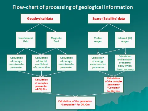
KINPRO® offers turnkey aerospace geophysical surveys, including full geological-geophysical interpretation of the results—optionally incorporating artificial-intelligence techniques.
We apply both widely recognized processing and modeling methods and our own proprietary interpretation technologies, developed in-house to address the broadest possible range of predictive and exploration objectives.
Examples of the geological problems we solve:
- Refining the deep structure of a territory, with the construction of basement structural-compositional maps and tectonic maps.
- Producing a prognostic-metallogenic map for solid minerals.
- Predicting primary diamond potential.
- Studying the morphology of sedimentary-cover structures and identifying predictive geophysical criteria for the location of oil- and gas-bearing geological structures.
Our specialists perform integrated geological-geophysical interpretation of aerogeophysical data, drawing on all available a priori information. Where required, we collect, analyze, and evaluate archival geological and geophysical information. Reprocessing and re-interpretation of previously acquired geophysical surveys is also available.
Interpretation methods we apply include:
- A range of filtering and transformation operations on source fields and geophysical models.
- Depth estimation of the upper and lower edges of anomalous bodies using various singular-point localization methods.
- Construction of volumetric models of effective-property distribution via 3D inversion algorithms.
- Local quantitative interpretation based on 3D modeling.
- 3D gravity-field modeling to build a consistent seismic-density model.
- Separation of fields from sources at different depths within the basement and cover, using automated modeling.
- Territory zonation by an integrated set of attributes.
- Fault mapping.
- Probabilistic-statistical analysis aimed at identifying indirect criteria and indicators of mineralization.
- Prediction of the structural framework of key reflecting horizons in the inter-profile space, using machine-learning algorithms.
- Additional proprietary methods that remain technically confidential at this time.
To optimize exploration time and cost, we always aim to complete aerospace geophysical surveys within a single field season, regardless of area or scale.
Drawing on aerospace sensing and potential-field data allows the placement of exploration wells (in GPS coordinates) to be defined with greater confidence, well in advance of 3D seismic acquisition, thereby significantly reducing the geological risks, timelines, and costs of exploration. In doing so, financial outlays are typically reduced by 40% and more, and exploration timelines are shortened by a factor of up to two.
Our company is uniquely positioned to prepare—on a case-by-case request, using our proprietary "density-contrast" know-how—and deliver to the client, following our aerospace geophysical studies, reliable data on the approximate hydrocarbon volumes within the license block under study. This information is structured to align with the conceptual frameworks of PRMS guidelines for Prospective Resources.
The probability of localizing geophysical anomalies and resources of hydrocarbons or commercial-grade minerals is consistently in the range of 90–95%, validated by drilling. It is supported by 25 years of project experience, confirmed during ground-based work—including 3D seismic and drilling—carried out by our clients.
KINPRO® is the only company on the Eurasian continent that assumes full contractual and financial responsibility for the technical integrity, acquisition quality, and interpretive accuracy of the geophysical deliverables it provides, in accordance with the terms of its contract with the client.